Navigating Geographic Challenges in Products - The Nine-Dash Line
By Samantha Bamberger

In this final post showcasing issues I've frequently discussed in my professional work - we're back in China and looking at another geographic assertion — the Nine-Dash Line. However, I wanted to switch things up and present it as an ArcGIS StoryMap.
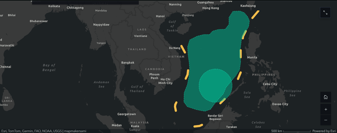
The Nine-Dash Line is the demarcation of China’s territorial claim in the South China Sea. The claim dates to 1947 and has evolved over the years to remove the Gulf of Tonkin and include Taiwan.[1]
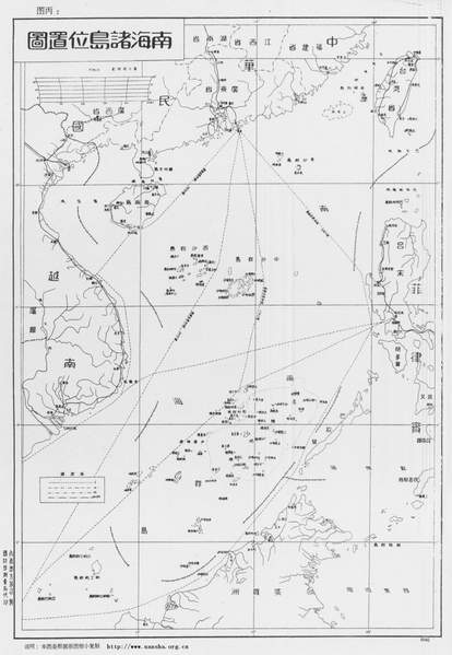
The number of dashes used to represent the line can range from nine to twelve and is referred to as the Eleven-Dash Line in Taiwan.[2]
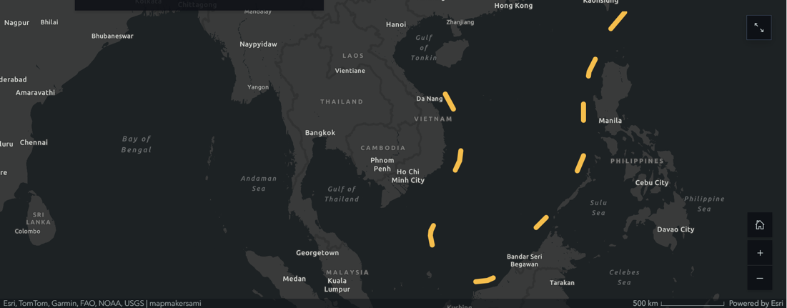
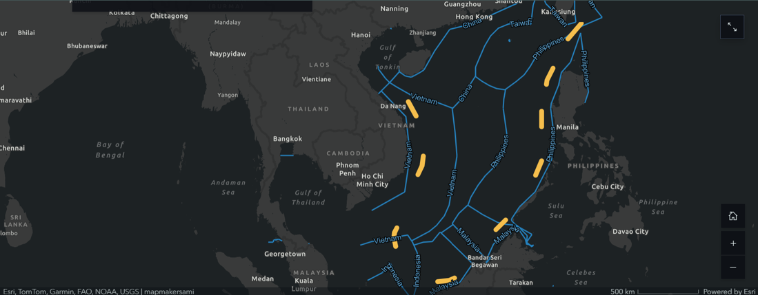
Intersecting areas of interest can lead to conflict, and the convergence of Exclusive Economic Zones (EEZs) throughout the South China Sea illustrate the competition. Notice that the claim encompasses islands and sea claimed by other nations, including Vietnam, Malaysia, Indonesia, Brunei Darussalam, and the Philippines.
As adopted through the 1982 United Nations Convention on the Law of the Sea (UNCLOS),[3] EEZs are areas of the ocean generally extending 200 nautical miles (230 miles) beyond a nation’s territorial sea, within which a coastal nation has jurisdiction over both living and nonliving resources.
Vietnam and the Philippines are the most vocal within the international community about contesting China’s claims. China has never filed this claim with the UN, but the Philippines contested this claim at a tribunal of the UNCLOS. In 2016, the ruling determined that China has no legal, historic claim to the demarcated area. The U.S. State Department specifically references the UN tribunal’s decision in its recent statement.[4]
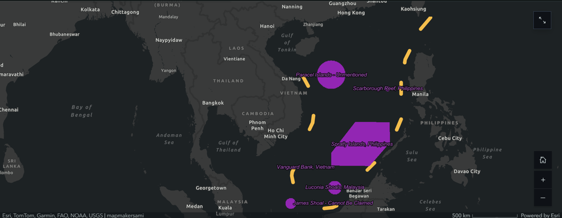
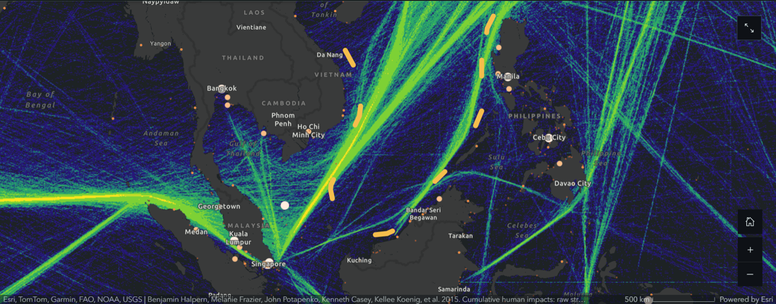
In solidarity with its Southeast Asian allies, the U.S. — along with the U.K. and France — frequently uses its naval power to patrol the South China Sea. The U.S. State Department asserts the ability to navigate the sea freely is lawfully allowed and essential for trade. U.S. naval patrols of the region often meet Chinese naval patrols.[5,6] China has also created man-made islands in the South China Sea for a stronger presence in the region.[7] This presence has led to Vietnamese and Filipino citizens becoming involved and periodically holding protests.[8]
While the U.S. asserts freedom of navigation, the South China Sea continues as a conduit for over USD 5 trillion of trade annually.[9] Any disruption to the current balance could diminish trade or move it elsewhere (such as the Arctic). In 2016, the U.S. State Department shifted policy from recognizing the tribunal’s arbitration as legal to rejecting Chinese claims.[10] The State Department renewed this stance in November 2023 amid a rising and tense political atmosphere.[11]
What isn't covered in the story map is how this issue ties back to product management. When handling geographic visualizations of China, you need to be very conscious of your audience. Vietnam and the Philippines have banned movies because maps in the background showed the Nine-Dash Line. The release of a recent blockbuster was banned in Vietnam and boycotted in the Philippines due to a drawing interpreted as depicting the Nine-Dash Line. (AP, The Diplomat). There are serious financial implications in the millions for not knowing about these sensitivities or just assuming something is ambiguous enough. You would be required to show this claim on maps in China but if you are not working in China, it's best to avoid the depiction of the claim whenever possible.
End Notes
1. https://books.google.com/books?id=zc5ZAgAAQBAJ
2. https://web.archive.org/web/20100105111857/http://www.atimes.com/atimes/Southeast_Asia/KL08Ae01.html
3. https://oceanexplorer.noaa.gov/facts/useez.html
4. https://pca-cpa.org/en/cases/7/
5. https://sites.tufts.edu/lawofthesea/chapter-three/
7. https://amti.csis.org/island-tracker/china/
8. https://www.aljazeera.com/news/2012/5/11/protests-in-philippines-over-china-dispute
9. https://media.defense.gov/2022/Jul/31/2003046333/-1/-1/1/10%20MOULTON_COMMENTARY.PDF
10. https://ge.usembassy.gov/u-s-rejects-chinas-unlawful-claims-in-south-china-sea-july-22/
11. https://www.state.gov/u-s-support-for-the-philippines-in-the-south-china-sea-6/